ARUNACHAL PRADESH
- Introduction. Arunachal Pradesh is an Indian state in north-eastern India. It was formed from the territory of the former Northeast Frontier Agency (NEFA), became a Union Territory on 21 January 1972, and became a state on 20 February 1987. It is bordered by the states of Assam and Nagaland to the south. Its international borders are disputed with Bhutan in the west, Myanmar in the east and China on the McMahon Line in the north. Ita Nagar is the state capital of Arunachal Pradesh. Arunachal Pradesh is the largest of the seven sister states of Northeast India in terms of area. Arunachal Pradesh shares a 1,129 km border with China’s Tibet Autonomous Region It has an area of 83,743 km2 (32,333 sq mi) and a population of 1,382,611. According to India’s 2011 census, Arunachal Pradesh has a population of 1,382,611 and an area of 83,743 sq km (32,333 sq mi). It is an ethnically diverse state, mostly inhabited by Monpa people in the west, Tani people in the center, Tai people in the east and Naga people in the south of the state. There are about 45 tribes / sub-tribes living in the state. The main tribes of the state are Adi, Nyshi, Galo, Tagin, Apatani etc. The Mushmi tribe has three sub-tribes, namely, Edo-Mushmi, Degaro-Mushmi and Mejo-Mushmi. Both the People’s Republic of China and the Republic of China claim a large part of the state as part of the territory of southern Tibet.. During the Sino-Indian War of 1962, most of Arunachal Pradesh was occupied and temporarily controlled by the Chinese People’s Liberation Army.
- History. In 1913-1914, representatives of the de facto independent state of Tibet and Britain met in India to define the boundaries of ‘Outer Tibet’ (with reference to China). Sir Henry McMahon, the British administrator, drew the 550-mile (890 km) McMahon Line as the border between British India and Tibet, placing Tawang and other areas in British India. The Tibetan and British representatives, including the McMahon Line, drafted the Shimla Agreement, but the Chinese representatives did not agree. The Shimla Agreement denies China any other benefits while refusing to agree to the agreement. The Chinese position was that Tibet was not independent of China and could not sign treaties, so the treaty was wrong, as was the case with Anglo-Chinese (1906) and Anglo. -Russian (1907) Convention. British records show that the condition for the Tibetan government to accept the new border was that China should accept the Shimla Convention. Since Britain was unable to gain acceptance from China, the Tibetan McMahon line was misunderstood. In 1935, Olaf Caroe, a Deputy Secretary of State, “discovered” that the McMahon Line was not drawn on official maps. The Survey of India published a map in 1937 showing the McMahon Line as the official border. In 1938, two decades after the Shimla Conference, the British finally published the Shimla Agreement as a bilateral agreement and the Survey of India published a detailed map showing the McMahon Line as India’s border. In 1944, the British established an administration in the area from Derang Zong in the west to Walaung in the east.
a. Sino-Indian War. India became independent in 1947 and the People’s Republic of China (PRC) was formed in 1949. The new Chinese government still misjudges the McMahon line. In November 1950, the PRC was ready to occupy Tibet by force, and India supported Tibet. Journalist Sudha Ramachandran argued that China claimed Tawang on behalf of the Tibetans, although the Tibetans did not claim that Tawang was in Tibet. What is now Arunachal Pradesh was established in 1954 as the Northeast Border Agency (NEFA) and Sino-Indian relations lasted till 1960. The resurgence of border disputes led to the Sino-Indian War in 1962, during which China occupied most of Arunachal Pradesh. However, China soon declared victory, McMahon returned to the line, and in 1963 returned Indian prisoners of war. The war ended barter trade with Tibet, although since 2007 the Indian government has expressed a desire to resume barter trade.
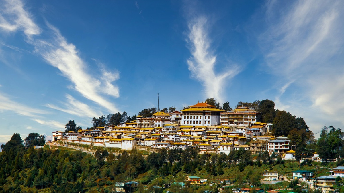
b. Renaming and statehood. The North East Frontier Agency was renamed Arunachal Pradesh after Sri Bibhabasu Das Shastri, Director Research and K.A.A. Raja, Chief Commissioner of Arunachal Pradesh on January 20, 1972, and it became a Centrally Administered Territory. Arunachal Pradesh became a state on February 20, 1987. Recent claims Tawang Monastery in Arunachal Pradesh is the largest monastery in India and the second largest in the world after Potala Palace in Lhasa, Tibet. It is one of the few Tibetan Buddhist monasteries that has survived the Maoist Cultural Revolution without any harm. In 2003, the Dalai Lama declared that Arunachal was actually part of Tibet. In January 2007, the Dalai Lama stated that both Britain and Tibet had recognized the McMahon Line in 1914. In 2008, he said, “Arunachal Pradesh was part of India under the agreement signed by the Tibetan and British representatives, according to the Dalai Lama. During the Indo-China War in 1962, the People’s Liberation Army (PLA) occupied all these territories (Arunachal Pradesh) but declared a unilateral ceasefire and withdrew accepting the existing international border. gone”. Claims on Tawang India has rejected these claims and informed the Chinese government that Tawang is an integral part of India. India reiterated this to China when the two Prime Ministers met in Thailand in October 2009. A report claiming that the Chinese army had briefly attacked Arunachal Pradesh in 2016 was denied by Indian Minister of State for Home Affairs Crane Rejeju. In April 2017, China strongly objected to the Dalai Lama’s visit to Tawang, as the US ambassador to India was scheduled to visit earlier. China has objected to the Dalai Lama’s previous visits to the region.
3. Geography Arunachal Pradesh is located between 26.28 ° N and 29.30 ° N latitudes and longitudes of 91.20 ° E and 97.30 ° E and covers an area of 83,743 km2 (32,333 sq mi). The highest peak in the state is Kangto, at 7,060 meters (23,160 feet). Nyegi Kangsang, Central Gorichen Peak, and East Gorichen Peak are other high peaks in the Himalayas. The mountain ranges of the state, in the far east of India, are described in historical Indian writings as “the place where the sun rises” and are named after the Aruna Mountains, which influenced the
- Climate. The climate of Arunachal Pradesh varies with altitude. The low-lying areas have a humid climate. Altitude areas (3500–5500 m) have sub-tropical highland climate and alpine climate. Arunachal Pradesh receives 2,000 to 5,000 mm (79 to 197 inches) of rainfall annually, with 70% -80% rainfall between May and October.
- Biodiversity. Arunachal Pradesh has the highest diversity of mammals and birds in India. The state has about 750 species of birds and more than 200 species of mammals. The forests of Arunachal make up one-third of the habitat within the hotspots of Himalayan biodiversity. In 2013, 31,273 km2 (12,075 sq mi) of Arunachal forests were identified as part of a continuous forest area (65,730 km2 or 25,380 sq mi, including forests of Myanmar, China and Bhutan) called Intact Forest Land. It’s called escape. There are two tiger reserves in the state namely Namdafa Tiger Reserve and Pukka Tiger Reserve.
- Flora. In the year 2000 Arunachal Pradesh was covered with 63,093 km2(24,360 sq mi) of tree cover (77% of its land area). It harbours over 5000 plants, about 85 terrestrial mammals, over 500 birds and Lots of butterflies, insects and reptiles. At the lowest elevation, mainly on the border of Assam with Arunachal Pradesh, are the semi-evergreen forests of the Brahmaputra valley. Much of the state, including the foothills of the Himalayas and the Patkai Hills, is home to the broad-leaved forests of the eastern Himalayas. Towards the northern border with Tibet, with increasing altitude, comes a mixture of eastern and northeastern Himalayan subalpine conifer forests followed by the eastern Himalayan alpine shrubs and meadows and finally rock and snow on the highest peaks. It supports many medicinal plants and its inhabitants are using 158 medicinal plants in Zero Valley of Ziro Subansari District.
- Fauna. The main species of animals are tiger, leopard, snow leopard, asiatic elephant, Sambhar deer, cheetah deer, barking deer, sloth beer, Mithuna (busfrontless), gore, dust, giant temple squirrel, marble cat, leopard cat. The state has identified a new sub-breed of the Holocaust Gibbon, named H.h. mishmiensis. Three new giant flying squirrels from the state during the last decade and a half were also explained. These were the Mechuka giant Flying Squirrel, the Mushmi Hills Giant Temple Flying Squirrel, and the Meibo Giant Flying Squirrel.
- Districts. Arunachal Pradesh consists of two divisions, namely East and West, each headed by a Divisional Commissioner and 25 districts, each administered by a Deputy Commissioner.
9. Economy. The chart below shows the trend of Gross State Domestic Product of Arunachal Pradesh, with figures of billions of Indian rupees at market prices through the implementation of the Ministry of Statistics and Program.
| Year | Gross Domestic Product (Billion ₹) |
| 1980 | 1.070 |
| 1985 | 2.690 |
| 1990 | 5.080 |
| 1995 | 11.840 |
| 2000 | 17.830 |
| 2005 | 31.880 |
| 2010 | 65.210 |
| 2014 | 155.880 |
The gross domestic product of Arunachal Pradesh was estimated at US $ 706 million at current prices in 2004 and US $ 1.75 billion at current prices in 2012. Agriculture is the mainstay of the economy. The term jham, a local term used for farming, is widely used among tribal groups, although it has not become as common as it used to be in recent years due to the gradual increase in other sources of income. Arunachal Pradesh has about 61,000 km2 of forests, and forest products are the next most important sector of the economy. Crops grown here include rice, maize, millet, wheat, pulses, sugarcane, ginger and oilseeds. Arunachal is also ideal for gardening and orchards. Its major industries are rice mills, fruit preservation and processing units and handloom handicrafts. Trade in saw mills and plywood is prohibited by law. There are many opinions in the state. Arunachal Pradesh accounts for a large percentage of India’s unused hydroelectric potential. In 2008, the Arunachal Pradesh government signed several memoranda of understanding with various companies planning about 42 hydroelectric schemes that will generate more than 27,000 MW of electricity. Construction of the Upper Siang Hydroelectric Project, which is expected to generate between 10,000 and 12,000 MW of electricity. Started in April 2009.
- Demographics.
| Population Growth | |||
| Census | Population | %± | |
| 1961 | 337,000 | — | |
| 1971 | 468,000 | 38.9% | |
| 1981 | 632,000 | 35.0% | |
| 1991 | 865,000 | 36.9% | |
| 2001 | 1,098,000 | 26.9% | |
| 2011 | 1,382,611 | 25.9% | |
Arunachal Pradesh can be divided into almost semi-separate cultural circles on the basis of tribal identity, language, religion and material culture: Tibetan-speaking Monpa region bordering Bhutan to the west, Tani region state, Mashmi to the east of Tani region. The Tai / Sangfu / Tangsa area bordering Myanmar, and the Naga area to the south, which also adjoins Myanmar. Between these are areas of migration, such as the Aka/Hruso/Miji/Sherdukpen area, between the Tibetan Buddhist tribes and the enemy Tani mountain tribes. In addition, isolated people are scattered across the state, such as slings.
Within each of these cultural spheres, one finds the population of the respective tribes who speak the respective languages and share the same traditions. In the Tibetic area, a large number of Monpatribes are found, with many sub-tribes speaking closely related but mutually incomprehensible languages, and a large number of Tibetan refugees. Within the Tani area, the major tribes include the Nyishi. Apatani also live among the drug addicts, but are separate. At the center, one finds mainly Gallo people, including large subgroups of Karka, Lodu, Lodu
Bogum, Lare, and Pugo, which extend as far as Ramo and Pailiboareas (close to Gallo in many ways. Are). In the east, Adi is associated with many sub-tribes, including the Padma, Pasi, Maniyung and Booker. Malang, while also within the general Adi circle, is quite different in many ways. Moving east, ldu, miju and digaru form a cultural-linguistic area.
Moving southeast, the Tai Khamti are linguistically isolated from their neighbors and culturally distinct from the majority of other Arunachalese tribes. They follow the Theravada sect of Buddhism. They also show considerable harmony with the Singpho and Tangsa Naga tribes of the region, all of which are also found in Burma. Khamptis and Singphos have a large population presence, even in the neighboring state of Assam. Naharkatiya, Narayanpur of Lakhimpur District of Assam. A group of them had recently migrated from Burma and Assam to Arunachal Pradesh. The Nocte Naga and Wancho Naga are the other two major ethnic tribes. The two tribes show great cultural similarities. Finally, the Deori tribe is also a large community of the state, with its own distinct identity. They are descendants of the priestly class of the Chatias who were allowed to continue their livelihood after the defeat of the Chutias. The Deoris are only one of the Arunachal tribes in the historical records – which shows that they were the first ethnic groups to settle in the Himalayas between Dibang Valley and Lohit District before the arrival of many other tribes in the region between 1600 and 1900. The literacy rate in official statistics has increased from 54.74% in 2001 to 66.95% in 2011. The literacy population is estimated at 789,943. The number of literate men is 454,532 (73.69%) and the number of literate women is 335,411 (59.57%).
- Religion. Arunachal Pradesh has a diverse religious landscape in which no single religious group represents the majority of the population. A relatively large portion of the population of Arunachal is a fan of nature (indigenous religions), and follows their own particular traditional institutions such as Nishi’s Nyedar Namlo, Rangfarah from Tangsa& Nocte, Medar Nelo from Apatani, Kargu Gamgi through Gallo. And the local religion under the umbrella of Doni Polo by Doni Polo Dera Adi. A small number of Arunachalis have traditionally identified themselves as Hindus, although this number may increase as the traditions of enmity are absorbed into Hinduism. Tibetan Buddhism is predominant in the Tawang districts, western Kameng, and isolated areas adjacent to Tibet. Theravada Buddhism is practiced by groups living near the Myanmar border. About 30% of the population is Christian. According to the 2011 Indian Census, the religions of Arunachal Pradesh break down as follows:-
- Ø Christianity401,732 (33.26%)
- Ø Hinduism421,876 (26.04%)
- Ø Donyi-Polo362,553 (23.48%)
- Ø Buddhism162,815 (11.76%)
- Ø Islam27,045 (1.9%)
- Ø Other (3.18%)
- Ø Not stated (0.48%)
In 1971, the percentage of Christians in the state was 0.79 percent. It increased to 10.3% by 1991 and exceeded 30% by 2011.
- Languages:-
- Ø Nyishi(20.74%)
- Ø Adi(17.35%)
- Ø Nepali(6.89%)
- Ø Tagin(4.54%)
- Ø Bhotia(4.51%)
- Ø Wancho(4.23%)
- Ø Assamese(3.90%)
- Ø Bengali(3.66%)
- Ø Hindi(3.45%)
- Ø Chakma(3.40%)
- Ø Apatani(3.21%)
- Ø Mishmi(3.04%)
- Ø Tangsa(2.64%)
- Ø Nocte(2.19%)
- Ø Bhojpuri(2.04%)
- Ø Sadri (1.03%)
- Ø Others (13.18%)
According to the 2011 census, the major languages spoken in the state are Nishi (20.74%), Adi (17.35%, including Adi Bhutia (4.51%), Wancho (4.23%), Assamese (3.9%), Bengali (3.66%). Hindi (3.45%), Chakma (3.40%), Uptani (3.21%), Mushmi (3.04%), Tangsa (2.64%), Nocte (2.19%), Bhojpuri (2.04%) and Sadri (1.03%).
Modern-day Arunachal Pradesh is one of the richest and most linguistically diverse regions in all of Asia, with at least 30 and possibly more than 50 different languages, in addition to their innumerable dialects and sub-dialects. Boundaries between languages are often associated with tribal divisions – for example, Apatani and Nyishi are tribal and linguistically distinct – but changes in tribal identity and alignment over time have also ensured that A certain amount of complexity enters – for example, Gallo is a language and apparently has always been verbally separated from Adi, while Gallo’s adi with the earlier tribal alignment (i.e., ” AdiGallong “) “) Has recently been fundamentally dissolved.
The majority of the indigenous languages of modern-day Arunachal Pradesh belong to the Tibetan-Burman family. Most of them belong to a branch of Tibetan Burmese, the Abu Tani language. Almost all Tani languages are native to Central Arunachal Pradesh, including (moving from west to east) Nishi, Apatani, Tagin, Gallo, Booker, Adi, Padma, Pasi and Minyong. Tani languages are characterized by relative homogeneity as a whole, which suggests a relatively recent origin and dispersion in the area of their present-day concentration. Most Tani languages are mutually understandable with at least one other Tani language, meaning that the region forms a dialect, as was once the case in most parts of Europe. Only Aptani and Malang are relatively unusual in this context. Tani languages are among the best read languages in the region. To the east of the Tani area are three practically indescribable and endangered languages of the Tibetan Burmese “Mushmi” group: Edu, Degaro and Meijo. The number of speakers of these languages is also found in Tibet. The relationship of these languages, with each other and with other regional languages, is still uncertain. Further south, one finds Sungfu (Kachin), a language spoken mainly by the large population in the Kachin State of Myanmar, and Nocte and Wancho languages, which differ from some of the Naga languages spoken in the south of modern Nagaland. Show commitment. To the west and north of the Tani area are found at least one and possibly four Bodic languages, including Dakpa and Tshangla. In modern India, these languages are used scientifically but, in usage, Monpa and Memba are given separate designations. Most of the Bodic languages spoken or closely related to these languages are found in neighboring Bhutan and Tibet, and the populations of Monpa and Memba live very close to these border areas.
Between the Bodic and Tani regions there are many almost completely undeclared and unclassified languages, presumably considered Tibetan-Burmese, exhibiting many unique structural and lexical features that may belong to the region. Both reflect a long history and a complex history of language interactions with neighboring populations. . These include Sherdukpen, Bugun, Harso, Koro, Miji, Bangru and Puroik/ Sulung. The high linguistic significance of these languages is denied due to their extreme lack of documentation and detail in view of their extremely endangered status. Puroik, in particular, is perhaps one of the most culturally and linguistically unique and important populations in all of Asia from a proto-historical and anthropological point of view, and yet practically no No authentic information can be found. Print.
Finally, in addition to the Bodic and Tani groups, there are also some migratory languages spoken mostly by migrants and central government employees who serve the state in various departments and institutions of modern day Arunachal Pradesh. have been. They have been classified as non-tribal under the provisions of the Constitution of India. Outside of Tibet Burman, Arunachal Pradesh is home to a single representative of the Tai family, spoken by the Tai Khamti tribe, which is closely associated with the Shan language of Myanmar’s Shan state. Apparently, Khampati is a recent arrival in Arunachal Pradesh, having migrated from northern Myanmar in the 18th and / or early 19th century.
In addition to these Indo-European languages, Indo-European languages are gaining ground in Assamese, Bengali, English, Nepali and especially Hindi in Arunachal Pradesh. Mainly as a result of the primary education system – in which classes are usually taught by Hindi-speaking immigrant teachers from Bihar and other Hindi-speaking parts of northern India, a large and growing section of the population is now a semi-Creole type. Speaks the language of Hindi as the mother tongue. Hindi serves as a language for most of the people of the state. Despite the linguistic diversity of the region, or perhaps because of it, English is the only official language recognized in the state.
- Transport
- Air. Itanagar Airport, a greenfield project serving Itanagar is being constructed at a cost of Rs. 6.5 billion in Holongi. Alliance Air operates the only scheduled flights to the state, which fly from Kolkata to Pasighat Airport via Guwahati. The route was launched in May 2018 under the government’s regional connectivity scheme UDAN, following the completion of a passenger terminal at Pasighat Airport in 2017. The government has proposed to promote them. Before connecting the state to roads, these airstrips were used for food distribution.
- Roads. The main highway of Arunachal Pradesh is Trans Arunachal Highway, National Highway 13 (1,293 km (803 miles); formerly NH-229 and NH-52). It originates from Tawang and spreads over most of the width of Arunachal Pradesh, then goes to Assam in the south and ends at Walkro. The plan was announced by the then Prime Minister Manmohan Singh in 2008 to be completed by 2015-16, but it could only work in 2018. NH-15 follows the southern border of Arunachal Pradesh via Assam. Access to Central Arunachal Pradesh is facilitated by the Bogiebel Bridge, an earthquake-resistant rail and road bridge over the Brahmaputra River in Assam, which was opened to the public by Prime Minister Narendra Modi on December 25, 2018.
NH-415 Services with a Super Highway Number Eta Nagar. The state-owned Arunachal Pradesh State Transport Services (APSTS) operates daily bus service from Eta Nagar to most of the district headquarters including Tezpur, Guwahati in Assam, Shillong in Meghalaya, and Dimapur in Nagaland. According to 2007, every village is connected by road thanks to the funds provided by the central government. Each small town has its own bus station with daily bus service. Contacts with Assam have boosted trade.
In 2014, two additional East-West highways were proposed: an Industrial Corridor Highway in the Lower Daman, and a Frontier Highway along the McMahon Line. The proposed alignment of the Frontier Highway has been published. China warns India against paving roads
- Railway. Arunachal Pradesh got its first railway line at the end of 2013 with the opening of a new link line from Harmoti to Naharlagan in Arunachal Pradesh on the Rangpara North-Merkongsilak railway line. Construction of the 33 km 1,676 mm (5 ft 6 in) 5 ft 6 in (1,676 mm) broad gauge railway line was completed in 2012, and the link became operational after the gauge replacement of the main line from Assam. The state capital Itanagar was added to the Indian Railways map on April 12, 2014 by the newly constructed 20 km Harmuti-Naharlagun railway line, when a train from Dekargaon, Assam, 10 km from the center of Itanagar, Naharlagun railway station. Arrived at, which was the total distance. 181 km. On February 20, 2015, the first train ran from New Delhi to Naharlagon, which was flagged off by Indian Prime Minister Narendra Modi. India finally plans to extend the railway to Tawang, near the Chinese border.
- Education. The state government, in collaboration with NGOs like Vivekananda Kendra, is expanding the relatively backward education system, which has led to rapid improvement in the state’s literacy rate. The major universities are Rajiv Gandhi University (formerly known as Arunachal University), which has 36 institutions offering regular undergraduate courses as well as degrees in Teacher Education and Health Sciences and Nursing, both public and private, under Indira Gandhi. Offers technology and medical sciences. University and also Himalayan University. The first college, Jawaharlal Nehru College, Pasighat, was established in 1964. The first technical university was established in 2014, the North East Frontier Technical University (NEFTU). Aloo, through Automobile Society India, New Delhi in West Siang District. There is also a Deemed University, North Eastern Regional Institute of Science and Technology as well as National Institute of Technology, Arunachal Pradesh, which was established on 18th August, 2010 in UPA (Ita Nagar Headquarters). NERIST plays an important role in technical and administrative higher education. The Directorate of Technical Education conducts examinations every year so that eligible students can pursue higher studies in other states. Of the above institutions, only the following institutions have been approved by the NAAC (National Assessment and Accreditation Council) in the order of their grades. Jawaharlal Nehru College, Pasighat (Grade A), St. Claret College, Zero (Grade A), Indira Gandhi Government. College, Tezu (Grade B ++), Rajiv Gandhi University (Grade B), National Institute of Technology, Arunachal Pradesh (Grade B), Dera Natting Government College, Ita Nagar (Grade B), Govt. College, Bomdila (Grade B), Donyi Polo Govt. College, Kamki (Grade B), and Rang Farah Government. College, Transformation (Grade C). There are also trust institutes like Pali Vidya Peth run by Buddhists. They teach Pali and Khumti script in addition to general education subjects. The Khumti are the only tribe of Arunachal Pradesh which has its own script. Scriptural libraries are located in many places in Lohit district, the largest of which is in Chowkham. There are two polytechnic institutes in the state: Rajiv Gandhi Government Polytechnic in Itanagar was established in 2002 and Tommy Polytechnic College in Basar was established in 2006. There are two laws. Colleges, namely the privately owned Arunachal Law Academy in Itanagar and Jute, the state-owned Jarbom Gamlin Government Law College in Itanagar. The College of Horticulture and Forestry is affiliated to the Central Agricultural University, Imphal.
- Insurgency. Main article: Insurgency in Arunachal Pradesh
Arunachal Pradesh faces threats from insurgent groups, particularly the National Socialist Council of Nagaland (NSCN), which is believed to have base camps in Changlong and Trap districts. These groups seek to reduce the Indian government’s influence in the region and to annex part of Arunachal Pradesh to Nagaland.The Indian Army is present along the Tibetan border to thwart any Chinese incursions. Under the Foreign (Safe Areas) Order 1958 (India), Inland Line Permits (ILPs) are required to enter Arunachal Pradesh through any of its check gates on the Assam border.
- Politics. Arunachal Pradesh suffered a political crisis between April 2016 and December 2016. Indian National Congress Chief Minister Nabam Toki replaced Jarbom Gamlin as Chief Minister of Arunachal Pradesh on November 1, 2011 and continued till January 2016. After the political crisis in 2016, President Raj came into power. Ordered to end his term as Chief Minister. In February 2016, Kalikho Pul became the Chief Minister when 14 disqualified MLAs were reinstated by the Supreme Court. On July 13, 2016, the Supreme Court quashed the order of Arunachal Pradesh Governor J.P. Rajkhowa‘s to adjourn the Assembly session from January 14, 2016 to December 16, 2015, which resulted in the imposition of President Raj in Arunachal Pradesh. As a result, Nabam Toki was reinstated as the Chief Minister of Arunachal Pradesh on July 13, 2016. But just hours before the floor test, he resigned as chief minister on July 16, 2016. He was replaced by Pema Khandu as the Chief Minister of INC who later became the Chief Minister. Joined the PPA in September 2016 with a majority of MLAs. Pima Khandu joined the BJP in December 2016 with a majority of more MLAs.
- Insurgency in Arunachal Pradesh. On July 13, 2016, the Supreme Court quashed the order of Arunachal Pradesh Governor JP Rajakhuwa to adjourn the Assembly session from January 14, 2016 to December 16, 2015, which resulted in the imposition of President Raj in Arunachal Pradesh. As a result, Nabam Toki was reinstated as the Chief Minister of Arunachal Pradesh on July 13, 2016. But just hours before the floor test, he resigned as chief minister on July 16, 2016. He was replaced by Pima Khandu as the Chief Minister of INC who later became the Chief Minister. Joined the PPA in September 2016 with a majority of MLAs. Pima Khandu joined the BJP in December 2016 with a majority of more MLAs.
- NSCN insurgency (1980-present). The National Socialist Council of Nagaland is a large ethnic nationalist separatist group. It was formed in 1980 to form a Greater Nagaland, which included Manipur, Nagaland and parts of the northern Kechar Hills (Assam). NSCN split in 1988 to form two groups, NSCN (IM) and NSCN (K). As of 2015, both groups have observed a ceasefire with the Indian government. The National Socialist Council of Nagaland-Khaplang is the second faction aimed at Greater Nagaland and was formed in 1988.
- The National Liberation Council of Taniland (NLCT). NLCT was active along the Assam-Arunachal Pradesh border, and its members belong to Tani groups of Thai people who are demanding Taniland. The group has no support from the local population of Arunachal Pradesh who are strongly pro-India and the group is now disbanded. Tani groups are one of the ethnic groups of North East India (variously known as Missing in Assam and in Arunachal Pradesh, Adi, Nishi, Galu, Apatani, Tagin, Arunachal Pradesh) as well as Loba in China which belongs to India. Live along the border
- United Socialist Council of Arunachal The United Socialist Council of Arunachal Pradesh was a small communist terrorist organization operating in the province. He was led by Gangte Tugging until his arrest on August 10 with state police and most of the USCA leadership. Tangong had been arrested twice before but escaped twice.


Leave a reply